

2026 Fire Danger System Updates
Background
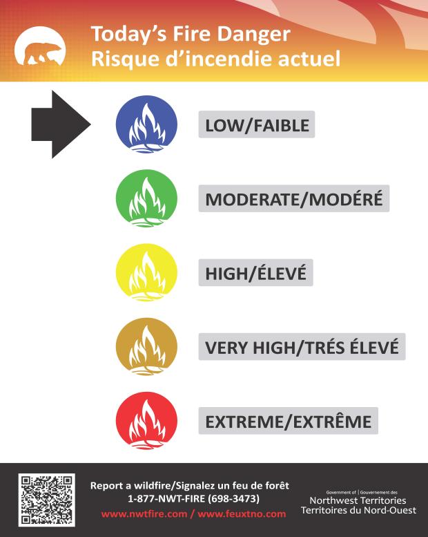
- The Fire Danger System in the NWT is being updated to reflect a five-part expression of fire danger for all public communication rather than the existing four-part expression (Low, Moderate, High, Extreme).
- This is a national commitment by all agencies to adopt a common expression of fire danger so all Canadians receive the same message about fire weather conditions wherever they are.
What is changing
- Fire danger will now be expressed as:
- Low
- Moderate
- High
- Very High
- Extreme
- All fire danger signage is being replaced to reflect these changes.
- The changes address the wide variation in potential fire behaviour between the High and Extreme fire danger ratings.
- In the prior system, High fire danger could indicate moderately vigorous surface fires all the way up to severe partial and full crown involvement (some or most of the tops of the trees burning) if a wildfire became established within conifer (evergreen) forest fuels.
- Very High indicates to the public when fire managers would expect to see a fire consistently burning through the tops of trees after it is established – making fires very challenging to contain.
- Extreme fire danger now points towards severe conditions where aircraft are likely to be ineffective on a wildfire which becomes established.
Rationale
- Adding “Very High” expresses an increase in the likelihood of new fires growing quickly and becoming more difficult to control.
- Extreme fire danger loses its meaning when there are too many “extreme” days.
- Extreme fire danger should be reserved for the most serious and urgent fire weather scenarios – and prompt all northerners to avoid using fire all-together if they can help it.
Public education
- Fire danger signage locations are being tripled – now including all staffed territorial parks in the NWT, partnerships with fire halls, and placement in other advantageous locations (i.e. boat launches, picnic areas).
- Indigenous language signage is being developed and distributed to better serve northerners.
- A public education campaign will be launched to support implementation and educate the public.
What to do based on fire danger
Get tips on being smart with fire on the land and what each fire danger level means:
What to look for
Look for these new fire danger signs in communities, parks, and other places you live and play to help you make good decisions while using fire on the land.
How Fire Danger is Calculated
Fire Danger is expressed based on the Fire Weather Index (FWI)– a combination of fire behaviour indices and fuel moisture codes which tell us how fires are likely to behave (i.e. whether the fire will likely be close to the ground, or reach the tops of trees) based on current weather and the fire environment.
For more information
- Canadian Forest Fire Danger Rating System
- Examples of fire behaviour in Jackpine stands based on FWI levels
- NWTFire
Other important information