

Ts’udé Nilįné Tuyeta
About Ts’udé Nilįne Tuyeta
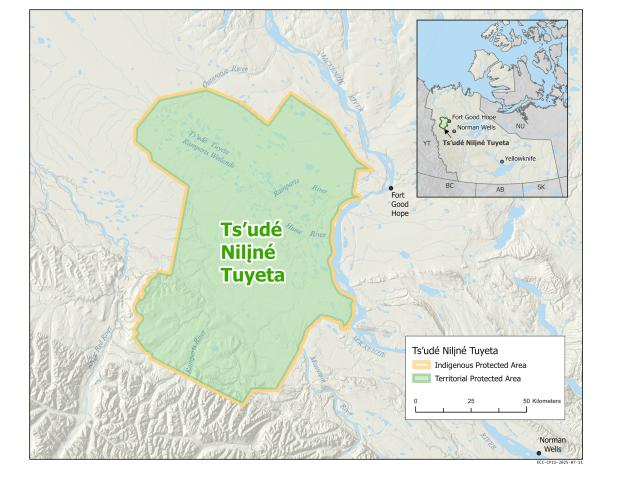
Ts’udé Nilįné Tuyeta - meaning ‘big tree river wetland,’ in Dene Kǝdǝ, the language of the K’áhshó Got’ı̨nę - is a 10,100 square kilometer Indigenous Protected Area that fully overlaps with a Territorial Protected Area.
Ts’udé Nilįné Tuyeta is named after the 4,600 sq. km wetland and river complex that is a crucial stopover for thousands of migratory birds and has sustained the K’áhshó Got’ı̨nę Dene and Métis for generations. Ts’udé Nilįné, also called the Ramparts River in English, flows from the foothills of the Mackenzie Mountains, meanders through a vast wetland, and empties into the Mackenzie River just below the Ramparts Canyon and the community of Fort Good Hope.
The protected area is an important cultural and spiritual gathering place for the K’áhshó Got’ı̨nę. The diverse landscape, extensive wetlands, and rich biodiversity have supported hunting, fishing, trapping, and other traditional activities for generations. The area is home to many sacred places, cultural sites, harvesting areas and traditional trails.
Ts’udé Nilįné Tuyeta Indigenous Protected Area and Territorial Protected Area was established in 2019 using K’áhshó Got’ı̨nę law, the Ts’udé Nilįné Tuyeta establishment agreement, and the Northwest Territories’ Protected Areas Act. The area was first recommended for protection by the Sahtú Heritage Places and Sites Joint Working Group in the Rakekée Go’ié Godi: Places We Take Care Of: Report in 2000.
The management and stewardship of the protected area is shared between the Government of the Northwest Territories and the K'ahsho Got'ine Foundation, representing the Fort Good Hope Dene First Nation, the Behdzi Ahda' First Nation, the Yamoga Land Corporation, the Ayoni Keh Land Corporation, and the Fort Good Hope Métis Local #54 Land Corporation.
Map of Ts’udé Nilįné Tuyeta
Resources
For other Ts’udé Nilįné Tuyeta documents, please visit the Protected Areas Registry.